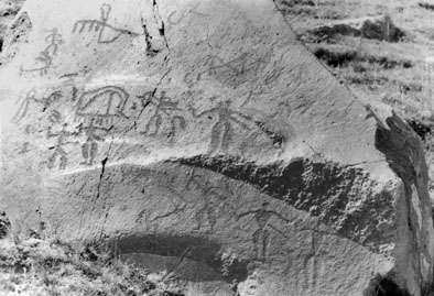
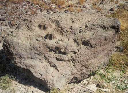
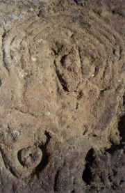
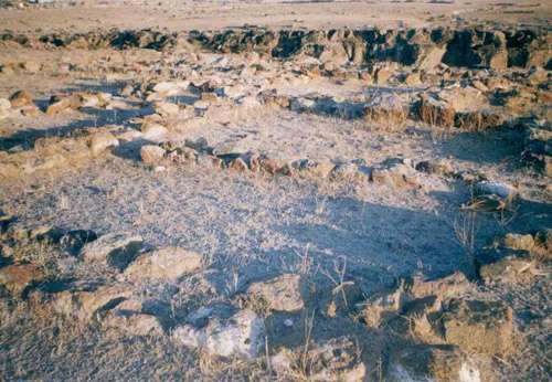
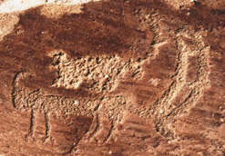
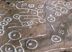
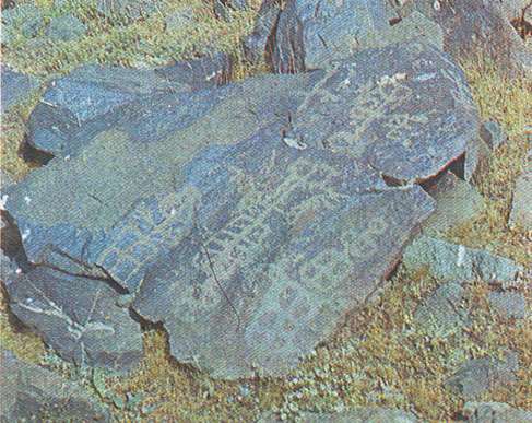
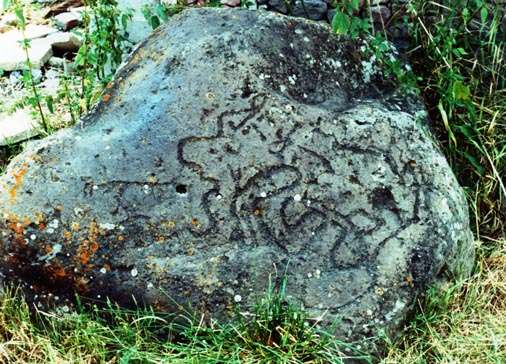
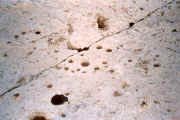
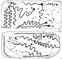
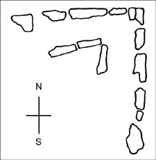
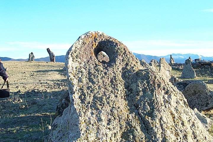
Metsamor settlement, metallurgical center, observatory and carved map

faluss 16hat.jpg (70231 bytes)

Located in Armavir Marz, near Ejmiatsin, by the Sev Jour River.


The site is a Bronze Age settlement and metallurgical center of 3rd - 1st Millennia BC, observatory of 2nd - 1st Millennia BC, an earliest center of worship.

The first discovered (1902) rock-carving of Armenia is located here, representing a water-grid map of Aragats Mountain irrigation system of pre-Urartian period (the picture above and the middle picture representing the plan of the water-grid).

16 phalluses unearthed from different parts of this site are now set up in a line: the vishap (stone-dragon) on the right, phalluses on the left (the picture below).


The carvings were noticed in 1902 (Mesrovb Ter-Movsessyan).

Distance from Yerevan: 35 km
Altitude: 900 m


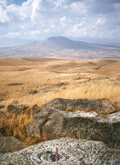
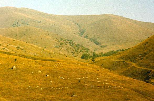
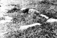
Aragats Petroglyph site and vishaps

Located in Aragatsotn Marz.


The highest peak in the Republic is the Aragats mountain (4090 m). The slopes of the mountain are covered with traces of civilization. There are many fortresses, vishaps, rock-carvings, irrigation systems of pre-Urartian period.
One may see town-fortress of Anberd at 2300 meters above sea level. It was built by the highest standard of fortification of its age (7th C. AD). There are about 20 rock-carvings and vishaps from 3rd - 2nd Millennia BC on the road from Anberd to the peaks of Aragats. Also one may see churches in Anberd, Byurakan and Tegher (9 - 14th CC. AD) and many other tourist attractions.


The carvings were discovered in 1909 (Mesrovb Ter-Movsessyan), 1913 (Grigor Ghapantsyan).

Distance from Yerevan: 55 km

Altitude: 2300 - 2500 m 

Geghama Petroglyph area


xm001' 7077-30.jpg (64547 bytes)

Located in Kotayk and Gegharkounik Marzes.


The highest point above sea level is Mt. Azhdahak (3597 m). The territory of Geghama Petroglyph Area is 2600-3200 meters above sea level. The region is mountainous, rich with caverns, alpine meadows, high mountain-chains. The Area is the largest known petroglyph area in the Republic of Armenia, as well as one of the best-preserved. The trip to the Area will take you through a very picturesque area of the Geghama Mountain Range and reward you with one of the most extensive unspoiled petroglyph ensembles in Armenia. The trail is a gradually ascending rocky path to the petroglyph located at slopes of volcanic peaks.
An admirable scenic view of Mt. Aragats (4091 m), Mt. Ara (2577 m), Mt. Hatis (2428 m), Geghama Mountain Range, Lake Sevan (1900 m) and Kotayk Valley is available from this vantage point. Also one may go to the lakes Akna (3020 m, 1.2x0.8 km) and Dragon (2710 m, 1x0.5 km).

The Rock-Art sites in Geghama Petroglyph Area offer us to learn and to view the past of Armenians, the native people of the Armenian Highlands.


There are many interesting archaeological sites here: 

a/ Cyclopean fortress Sevaberd (Black fortress), big defense construction, unique example of Armenian fortification of the period, on the bank of reservoir, on 2100 m, dates back to 3rd - 2nd Millennia BC.

b/ Fortress-observatory Astghaberd (Star fortress), on the 3100 m, dates back to 4th - 2nd Millennia BC.

c/ Vishaps, cromlechs and other megaliths.


One may see 1000-1500 rock-carvings in following sites: Astghaberd, Ardaranots, Erankyun, Baderi Lchak, Artavazd, Hovit, Sarategh, Seghan, Aghbyur, Aghvesadzor, Paytasar, Agravi Lich, Qarakoghm, Arevner, Hegheghat, Karmir Qar, Peghatso, Qarapat, Sayl, Swastika, Tsul, Zinvor, etc.


The carvings were discovered in 1913 (Levon Lisitsian), 1951 (Alexander Demyokhin ).

Distance from Yerevan: 50 km

Altitude: 2500 - 3100 m


Small Paytasar petroglyphs

There are about 500 rock-carvings from 4th - 2nd Millennia BC, many pictures of dragons among them.

On the North slope of Mt. Small Paytasar (3177 m) one may see "Mammoth" picture Geoglyph.

Meteor crater near Azhdahak peak

meteor picture (58886 bytes)

The meteor crater is seen, connected with the image of bolide in Sevsar ancient astronomical observatory, the result of impact of big meteorite.


Diameter 28 m, 27.3 m (S-N) D=30,3 m (W-E), big axis of ellipse 35.6 m, depth - 4 m.

Calculations prove that such a crater might have been formed by the impact of a meteorite of 80-300 kg and a velocity of 20 to 10 km/sec. When the meteorite (or its fragments) and the traces of its impact are found in the crater, the time of the collision may be scientifically defined. This will afford the opportunity to more precisely define the absolute age of the Sevsar astronomical complex, dating back supposedly to 2nd-1st Millennia BC.


The crater were discovered in October 26, 1998 (Karen Tokhatyan).

Distance from Yerevan: 55 km

Altitude: 3275 m 


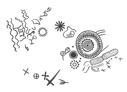
Armavir pictograms and sculptures

Located in Armavir Marz, near Armavir village. 


Armavir, one of the capital cities of Ancient Armenia, was a magnificent fortress and settlement. During the Urartian period (Ararat or Van Kingdom, Biaina) the city was called Argishtikhinili. Throughout centuries the city has been a major political, cultural, and religious center. Armavir is famous for its Greek inscriptions from the Hellenistic period. Inscriptions here were first studied in 1927.

The picture above represents a stone model of a sanctuary. On the surface of the huge rock-piece there are two well-preserved sculptures (7-8 cm high) which remind five-sided temples or ziggurats.

The picture below represents a detail of the monument: a solar-faced creature with quintuple halo on the right of the composition and some carved pictograms.


The carvings were noticed in September 30, 2001 (Karen Tokhatyan, Artak Movsissyan, Hamlet Martirossyan).

Distance from Yerevan: 55 km

Altitude: 900 m


Sevsar ancient astronomical observatory

ss01 tes armaxan' 6397-34.jpg (71390 bytes)

ss01 gcagir''.jpg (18791 bytes)

Located in Gegharkounik Marz, above Geghovit village, not far from Lake Sevan, the emerald of Armenia, 1900 m above sea level. In ancient times it was called Geghama Sea. The Sevan Basin is rich in archaeological and historical monuments.

One may see an ancient observatory with a unique image of bolide carved on a huge stone block, astronomical calendars and pictograms from 3rd - 1st Millennia BC.
There are 15 pictured rock-pieces within an area of 50 by 20 m. Observations allow us to conclude that the big round image represents a bolide, and the adjoining pictures are constellations. Thus, we may assume that this is a stellar map, which shows a sector of the sky from which the bolide descended. Supposing that the three lines on the right point in the direction of the bolide's flight, we shall see Azhdahak Mountain standing there, with a little (28 by 36 m and 4 m deep) crater behind.


The complex were discovered in 1965 (Suren Petrossyan).

Distance from Yerevan: 145 km

Altitude: 2500 - 2600 m 


Shamiram settlement and pictograms

Located in Aragatsotn Marz, near Shamiram village.


About 10 petroglyphs and carved pictograms may be seen on the stone surfaces of the cromlechs: circles, stylized images of man and animals.
The site dates back to 2nd - 1st Millennia BC. Nearby are Bronze and Iron Ages settlements.


The carvings were discovered in 1969.

Distance from Yerevan: 55 km

Altitude: 1200 m.

Syunik Petroglyph Area

Located in Syunik Marz, on the slopes of Tsghuk (3584 m) and Ukhtasar (3169 m) Mountains.


Pictures carved on the rocks in 5th - 4th Millennia BC testify to the fact that people lived here from time immemorial. One find the whole range of Armenian fauna in these pictures. The approximate quantity of rock-carvings here are thousands, but 50-100 rock-carvings are the most accessible.


The carvings were discovered in 1966 (Grigor Karakhanyan, Pavel Safyan).

Distance from Yerevan: 240 km

Altitude: 3000 - 3300 m 

Vardenis stellar maps

Located in Gegharkounik Marz, near Vardenis Mountain Pass.


The roads connecting Armenian Highland with outer world passed through the territory of Gegharkounik. One of the Silk Road legs passed through this very mountain Pass joining Arpa Valley with Sevan Basin (now linking the region centers  Eghegnadzor and Martuni, 65 km). Due to this there is a significant number of architectural constructions in the province: lodgings, bridges, fortresses.

Most remarkable are the 10 sky maps astronomically dated back to 29-26th centuries BC, which were used for geographic orientation (the picture above demonstrates some of the sky-maps; the picture below is a fragment; both pictures are chalked for a better photographic contrast).

The preserved 10 stellar maps may represent the remains of an ancient  astronomical center.

The site is located approximately 5 km East from Sevsar ancient astronomical complex.


The carvings were discovered in 1966 (Suren Petrossyan).

Distance from Yerevan: 150 km

Altitude: 2400 m 

Qouchak pictograms  

Located in Aragatsotn Marz, near Qouchak village, near the water reservoir.


About 60 carved pictograms, mainly geometric symbols, probably letter-like linear script, from the Iron Age (2nd - 1st Millennia BC) may be seen here. 50 of them are under the water for 8 months a year (November - June). Nearby are the ruins of three cyclopean fortresses, Iron Age settlements, and vast burial fields.


The carvings were discovered in 1967 (Suren Petrossyan).

Distance from Yerevan: 45 km

Altitude: 1850 m


Navasar Petroglyph Area

Located in Syunik Marz, on the slopes of the second peak of RA - Kaputjugh (3904 m), near Mesropavan village (by the name of the creator of the Armenian alphabet - Mesrop Mashtots, 360-440 AD, a great illuminator and pioneer of a new culture).

The study of pre-Mashtots writing symbols and Mesropian letter-forms are of capital importance for Armenology. There are number of written testimonies proving the existence of writing in Armenia before Mashtots.
Numerous examples of pre-Mashtots writings are evident in archaeological artifacts and especially rock-carvings featuring thousands of carved pictographic symbols. The Armenian Highland, a cradle of rock-carvings, has also been the birth place of various writing systems.
Great Armenian historians Koryun and Movses Khorenatsi report that having abandoned worldly pursuits, Mesrop Mashtots retired to the Goghtan Region, in the Vaspurakan Province, where he led a secluded life and converted the local population to Christianity. Here, in fact, is where the site of Mashtots's living cave is located, around which a lot of rock images were discovered.
The sum of historical, geographical, archaeological (
Bronze Age settlements and burials may be seen nearby) and folklore data leads us to conclude that having lived there for many years, Mashtots certainly should have seen the nearby rock-images rich in ideograms, and has used them while creating the letter-forms of the Armenian alphabet.


The rock-carvings were discovered in 1968.

Distance from Yerevan: 350 km

Altitude: 2800 - 3300 m 

Kakavadzor carved map

Located in the Aragatsotn Marz, near the village of Kakavadzor.


One may see the ruins of an Iron Age settlement and a cyclopean fortress in the northern part of which a carved map (on the tufa ground) o
f pre-Urartian period  (2nd - 1st Millennia BC) has been preserved.

The picture below represents the carved map of the irrigation system. The site is in danger because of the newly constructed dwellings not far from it.


The carving were noticed before 1973 (Koryun Mkrtchyan).

Distance from Yerevan: 65 km

Altitude: 1700 m 

Qarvachar Petroglyph Area 

Located in Qarvachar Region of Artsakh, on the slopes of  Erakatar and Toli Mounts, on the banks of the Al, Sev and Zalkh lakes.

One of the numerous Rock-Art sites in this petroglyph area.


The rock-carvings were noticed before 1981.
Distance from Yerevan: 250 km

Altitude: 3000 - 3300 m

Agarak Sanctuaries and carved stellar maps

Located in Aragatsotn Marz, between Agarak and Voskehat villages.


Numerous holes, hollows, and deep furrows linking them, possibly have had metallurgical function (as it is in Metsamor). Some of the hole groups might had astronomical meaning.

Beginning from 2001 excavations are held in the site by the Institute of Archaeology and Ethnography of National Academy of Sciences of RA. The results of the excavations prove that the area had been populated at least since 4th Millennium BC, up to Late Middle Ages.


The carvings were noticed in 1989 (Margarit Hovhannissyan).

Distance from Yerevan: 30 km 

Altitude: 1000 m

Balahovit pictograms

Located in Kotayk Marz, near Balahovit village. 


Two red-black tufa tombstones  (1.5x0.7 m) in the medieval cemetery. The snake-like pictograms on their surfaces

are similar to Metsamor and Kakavadzor analogous carvings.


The carvings were noticed in 1989 (Ashot Grigoryan).

Distance from Yerevan: 15 km

Altitude: 1200 m 


Koghes pictograms

Located in Lori Marz, near Stepanavan, by Koghes village.


Two km to the North of the village, on the left bank of the Dzoraget canyon one may see 5 cromlechs, and a stone compass. There are 10 carved pictograms on the surfaces of the stone compass, reminding linear script, and dating back to 2nd - 1st Millennia BC.
 

The carvings were discovered in 1990 (Hakob Tonakanyan).

 Distance from Yerevan: 160 km

Altitude: 1500-1600 m


Voskehat Petroglyph Site

Located in Aragatsotn Marz, near Voskehat village.


About 130 rock carvings may be counted here dating back to 4th - 2nd Millennia BC...

The rock-carvings are on the eastern slope of Lusakatar mountain. Eight expeditions during 1997-2003 revealed, mapped and photographed hundreds of images, located between Agarak and Aghavnatoun villages. Nearby are Early Bronze Age settlements and cromlechs which help to date the Rock-Art site. Two km to the North the Agarak sanctuary is  situated.

The discovery of this site is very important because it has miraculously survived on such a crossroad of numerous conquests, in Ararat Plain. The site is also unique by its low (in comparison with others) position from the sea  level.


The carvings were discovered in 1990 (Karen Tokhatyan).

Distance from Yerevan: 25 km

Altitude: 1050 - 1200 m

Geghard pictograms

Located in Kotayk Marz, near Geghard village.


Anthropomorphic linear pictograms are carved on the eastern side of the big stone inside the arch gate of Geghard monastery (4th c. AD).


The carving were noticed in 1991 (Hakob Tonakanyan).

Distance from Yerevan: 30 km

Altitude: 1200 m 

Qarahounge ancient astronomical observatory

Located in Syunik Marz, near Sisian town.


Describing Qarahounge is not easy; one must see it. Qarahounge (or "Zorats Qar" – Mighty Stones) dates back to 5th - 2nd Millennia BC. The scholars believe that they were intended for astronomical observations. It may be a prototype for Stonehenge-like observatories.

There are one carved calendar (?) and one goat-like rock carving.


The rock-carvings in Qarahounge were discovered in 2000 (Karen Tokhatyan, Artak Sargsyan).

Distance from Yerevan: 220 km

Altitude: 1780 m 

<Go to Top>

©ARARA-T  Contact Webmaster